MT HOOD WEATHER
INTRODUCTION
On a sunny winter day, Mt. Hood can feel like a respite from the gray, cloudy weather that dominates winter in Portland, Vancouver, and the Gorge. When storm cycles blast through, Mt. Hood is anything but a sunny, tropical vacation – It’s that exact storminess, the wind and dumping snow, that make it an awesome place to ride all winter long.
While Mt. Hood might be located in a mountain range, namely the Cascades, it’s merely 112 miles from the Pacific Ocean. This puts it squarely in a maritime climate, and that puts the ski areas right in the path of powerful storms. What’s this look like in numbers? Average snowfall at Timberline and Meadows is about 400” a year – more than 33 feet! Skibowl, lower in elevation, averages about 300” per year. This is more than Park City (355”), more than Snowmass (300”), but way less than Mt. Baker (641”). Still, 33 feet of snow a year is pretty darn respectable. It may not be the dry “champagne” powder seen in Utah and other inland resorts, but it’s plenty dry to call it “powder” much of the time!
Predicting all this snowfall is tricky. Why? Because those Pacific storms can come from many directions, they vary wildly in temp and moisture content, and they can slam into cold continental air trapped on the east side of the Cascades. That’s why you need my daily forecast. But we’re not here to talk about the forecast. We’re here to talk about the general weather patterns on Mt. Hood.
GENERAL WEATHER PATTERNS ON MT. HOOD
Let’s start by saying that some of these storms can wreak havoc the ski resorts – winds blow strong enough to shut down lifts and knock over trees; snow falls at rates high enough to bury cars in parking lots; massive rain arrives in the form of atmospheric rivers (aka the Pineapple Express, a long fetch of moisture that stretches across the Pacific Ocean and divests itself of moisture on the slopes of Mt. Hood); and finally, the combo of warm air to the west and cold to the east can result in massive ice storms. So, what’s best?
THE BEST WEATHER FOR POWDER
Let’s assume you like to ride powder. The best possible scenario for you is a system dropping down from Alaska and running into warmer, wetter air from the tropics. It’s not a frequent setup, but it will result in massive snowfall, massive powder snowfall to be exact. Magic is at play here. By magic, I mean orographic precipitation. Keeping this simple, we define “orographic precipitation” as “terrain-enhanced snowfall”. Essentially, wind hits a barrier, lifts the air, forms clouds, and all the moisture falls out of them. If it’s cold enough, this forms snow. If the wind is strong enough (25+ mph out of the NW for Mt. Hood), snowfall often exceeds model predictions by 50-100%. Orographics are particularly strong on Mt. Hood because it’s a standalone 11,249′ volcanic peak rather than just one bump in a continuous 10,000’ range. Truly amazing!
NEXT BEST FOR POWDER
Similar powdery results arise from storms that come straight out of the west and encounter Mt. Hood: cold enough temps for snow, enough orographic assistance for enhancement of snowfall, and a powder day for you.
ATMOSPHERIC RIVERS AND THE PINEAPPLE EXPRESS
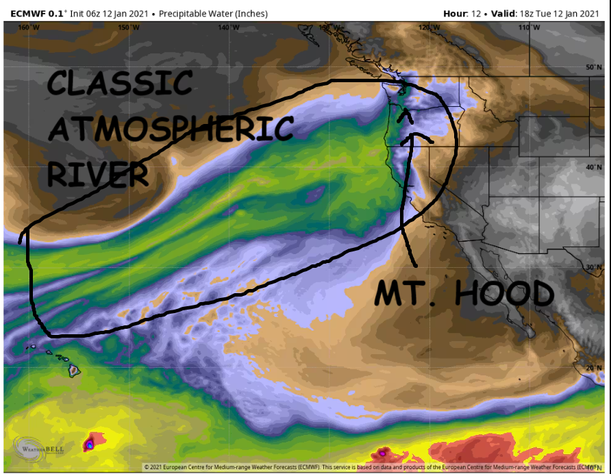
Things get trickier when storm systems come out of the SW, or when the flow into Mt. Hood is from the SW. These systems are warmer, and they’ll often raise temps above freezing at the base of Meadows (5300’) and even Timberline (6000’). Skibowl, Summit, Teacup, and Cooper Spur often end up with rain in these systems. Not always, but often.
PINEAPPLE EXPRESS
SW is also the direction of the dreaded Pineapple Express: a warm atmospheric river that taps into tropical moistures. These storms can dump several inches of rain on the slopes over the course of a day. Seeking snow up high doesn’t work – the snow level often rises to 10,000’ with the Pineapple Express! Don’t worry – this doesn’t happen all the time. Some years have more pineapples than others, but I’d guess the average is 2-3 of these events each year.
ICE STORMS AND STORM RECOVERY
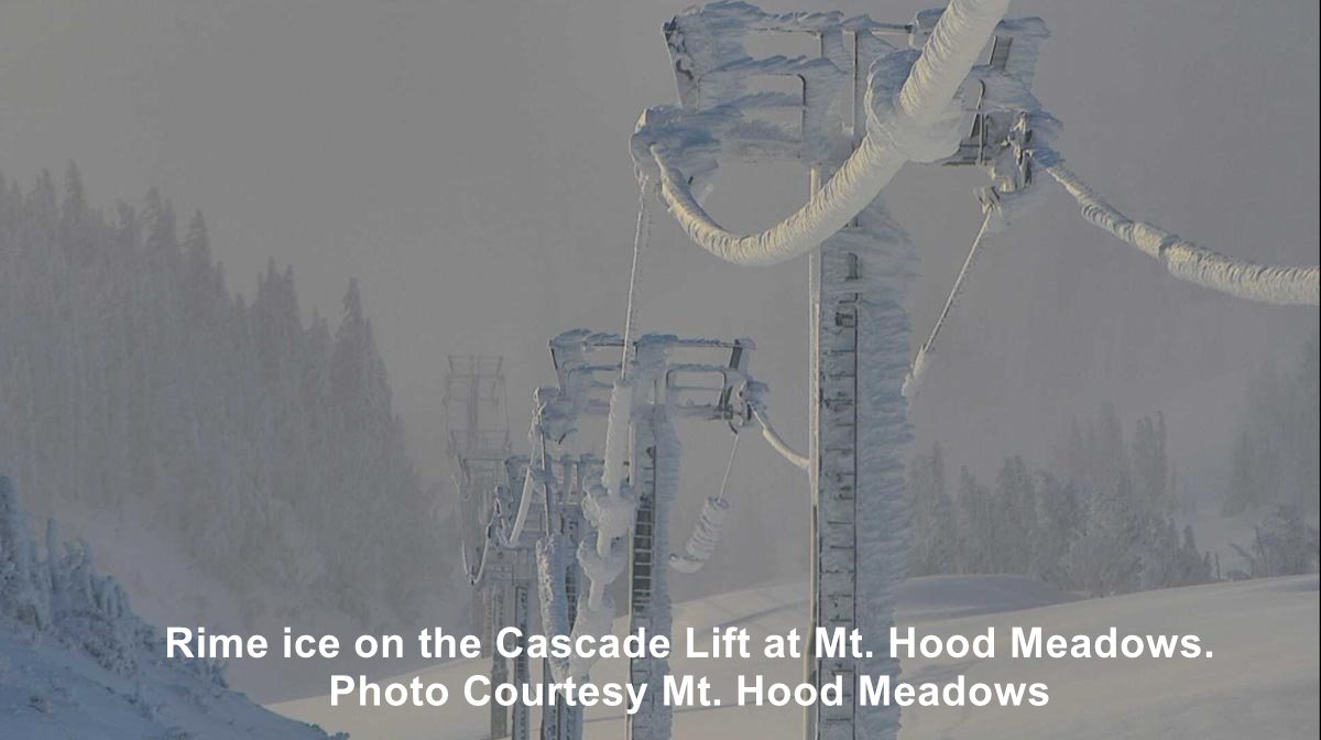
Finally, we have the messiest of situations: sometimes cool air will settle in on the east side of the Cascades. Warmer, wetter systems push in from the west. Or… a system moves in from the Pacific with just the right path where there’s cold air to the north and warm air to the south. Precipitation falls through these varying temperature layers and results in snow, snain, and ice buildup on lifts.
Many photos and videos are out there of what the resorts like to call “storm recovery” or “access restoration”. To keep it simple, let’s say that baseball bats are great for deicing chairs, and only brass hammers can be used to deice more delicate parts of lifts. Deicing can take hours or days depending on the weather that follows these storms. Practice patience, and be kind to the resort employees – they’ve probably been up since way before sunrise digging things out and beating ice off structures.
HIGH PRESSURE, SUNSHINE, AND SPRING SKIING CONDITIONS
But it’s not just storms that affect Mt. Hood. Long periods of dry, warm, sunny weather result when a ridge of high pressure settles in. Inversions – warmer air above than below – often result from this pattern. Daytime temps on the mountain can soar, even in winter, to the 50s or higher. Overnight, thanks to the long period of darkness and a cool (pun intended) phenomenon known as “radiational cooling”, the snow will refreeze despite the above-freezing temps.
These high pressure ridges can be quite persistent and often last longer than forecast models initially predict. This can make for fun corn snow conditions and goggle tan lines in the middle of winter, but the real secret is skate skiing – these freeze-thaw cycles make for world-class skate conditions at Meadows Nordic and Teacup Nordic Club. Best part? It’s a great complement to alpine skiing or snowboarding – when the conditions aren’t the best for lift-serve riding, they are downright awesome for skating.
AVALANCHE HAZARDS
While avalanche forecasting is not my specialty, a brief discussion of the hazards on Mt. Hood is important. If you want to be safer in the resort, and especially if you want to backcountry ski, familiarize yourself with the Northwest Avalanche Center and their stellar backcountry conditions reports.
Basically, we have a few repeating hazards that contribute to avalanche danger: a highly varied snowpack due to temperature and precipitation-type changes, wind loading on leeward slopes, and frequent upside-down snow events. What’s upside down? I’m glad you asked! It’s when warmer, wetter, heavier snow falls atop cold, dry, fluffy snow. These hazards are not an exhaustive list – again, go to an avalanche specialist and take an AIARE Level 1 course to familiarize yourself with the hazards (and the joys) of backcountry skiing.
BEST AND WORST SNOW YEARS
Like any ski resort anywhere, Mt. Hood has good years and bad years. This is influenced in a large part by the El Nino Southern Oscillation (ENSO), a cycle that involves changes in Pacific sea surface temps and related features.
EL NIÑO VS LA NIÑA
Generally speaking, La Nina episodes (cool sea surface temps in the Pacific along with other features) are colder and wetter in the Pacific Northwest. There’s a strong correlation between a strong La Nina and a big snow year on Mt. Hood. El Nino years (warmer sea surface temps) are somewhat correlated with warmer, drier years, but the correlation isn’t as strong. We can’t forget to mention the neutral years – anything can happen then! Check the current ENSO status here. Also related: the Madden-Julian Oscillation, but we’re not diving deep into that shorter-term cycle here. You can read more about it if you want!
BEST AND WORST SNOW YEARS
The biggest snowfall years on Mt. Hood (according to records from Timberline Lodge) were 73/74 (strong La Nina), 96/97 (weak La Nina transitioning to neutral), 98/99 (strong La Nina), and 01/02 (weak La Nina transitioning to neutral). Worst years? 76/77 (weak El Nino), 80/81 (neutral), 04/05 (weak El Nino), and 14/15 (weak El Nino). ENSO (El Nino Southern Oscillation) status provided by NWS Climate Prediction Center.
CONCLUSIONS
What can we conclude from all this? Well, let’s keep in mind the sample size isn’t huge; ENSO data only goes back to 1950. The strongest correlation is definitely between a strong La Nina and a cold, wet, snowy winter on Mt. Hood. Vote for that for every year!
CLIMATE CHANGE IMPACTS ON MT. HOOD
Since 1850, average temps on the planet have risen over 2 degrees Fahrenheit. Looking at this another way, the earth is, on average, two degrees (or more) warmer than it was if you average all the years between 1910 and 1999). Nine of North America’s 10 hottest years have been after 2001; the tenth was 1998. There’s no denying that the planet is warming. For our purposes, the question is about the impact it will have on climate change. As an insider in the snow sports industry, I can tell you that the resorts are trying to widen their operations to account for potential impacts.
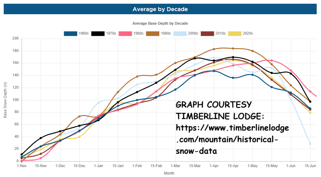
AVERAGE SNOWFALL OVER TIME
If we talk about average snowfall at 5300-6000’, the bases of Meadows and Timberline, we’re not seeing a noticeable impact yet. Timberline has this great graph of snowfall by decade. In theory, rising temps should cause the snow level to be, on average, higher, and it should cause temps at the resorts to be warmer. In other words, the powder will be less powdery. Over time, it will trend heavier. Another interesting effect of warming is the capacity for the warmer air to hold more moisture than colder air. Generally speaking (leaving aside all the special situations), warmer air should actually increase precipitation totals on Mt. Hood over time, as we’re tapped into Pacific moisture. That won’t necessarily be snow – warming temps mean more rain too, but it’s an interesting side effect.
ANECDOTAL OBSERVATIONS
Anecdotal thoughts on climate change… I’ve been playing in the snow on Mt. Hood since 1997, and I’ve been skiing in the Cascades since 1987 or so. Around here, it seems the low-elevation snowpack has lessened over time, and it seems the snow storms have ended earlier in spring each year. But that’s just anecdotal evidence based on my memory. Perhaps you (or I) will care to do the digging on that data at some point. Memory is fallible!
PRACTICAL TIPS FOR SKIING AND SNOWBOARDING ON MT. HOOD
So, you’ve chosen to go skiing, snowboarding, hiking, snowshoeing, snowmobiling, sledding, or some other snow sport activity on Mt. Hood. What next? For goodness sake, please read my forecast before you go. I mean, I read it and rely on it, and I promise it’ll help you out. Mt. Hood’s weather is dynamic – it can be sunny and 40 degrees in the morning and a full-on blizzard in the afternoon. Don’t head up based on what you see on a webcam in the morning. Read the forecast. Carry emergency gear (shovel, blankets, food, water, flashlight, external battery, shewee, tire chains, bag of sand or kitty litter) in your car.
DON’T WANT TO DRIVE?
Mt. Hood has the closest ski resorts to the Portland – Vancouver metro area. This means weekends can be particularly busy, sometimes so busy that all the resorts fill up. Busiest days, surprisingly, tend to be Friday and Sunday, although Saturday is plenty busy too. There are several transportation companies that can get you to the mountain, most notably (and cheaply) the Columbia Area Transit Gorge to Mountain Express shuttle from Hood River.
BEFORE YOU GO
If you’re heading up to ride lifts, check the ski resort conditions pages before you go. Meadows is particularly good about giving early-morning predictions of what the day holds on the slopes. They’re reading my forecast, and they’ll let you know if conditions will change, if the wind will shut down the lifts, or if access will be delayed by storm recovery operations. I guess I should say that I write the Meadows conditions report most weekends!
SUMMER: THE FORGOTTEN SEASON
Last tip: don’t forget about summer on Mt. Hood. You can ski or snowboard at Timberline pretty much year round (November through September – yeah, you read that right). They have a summer bike park too! Meadows is covered in wildflowers for much of the summer. Not only that, but a summer encounter with leftover snow will put a smile on your face. The resorts are a great place to watch meteor showers, and Meadows has movies on the deck in the summer when the sun sets at a reasonable hour.
FINAL THOUGHTS
Number one: Mt. Hood’s weather is dynamic thanks to its proximity to the Pacific Ocean. Read a human-written forecast, not an app, before you go up. Number two: get used to storm skiing, because it’s one of the fun, quirky things about Mt. Hood. You didn’t move here for Utah-style bluebird powder days – you moved here for a more Oregon style of skiing. Three: widen your repertoire. Take up skiing, snowboarding, skate skiing, snowshoeing and whatever else you can think to do on the snow – that’ll widen the range of days that are fun for you!
Be like a local: embrace the excitement of skiing on a volcano that pokes up into the extreme weather of the jet stream. Embrace the dumping snow and the storm skiing. Take up ALL the winter sports. And for goodness sake, read my forecast before you go so you’re dressed right, waxed right, and packed right for the incoming weather. See you out there on the slopes!

Have an awesome day.
Love, Temira