MT. HOOD SNOW FORECAST

Hey skiers and snowboarders! It’s a good thing it’s calm weather this week, because most of the models I use for forecasting are through UW. That website is down this morning. Fortunately, at least some of the info is available elsewhere, and fortunately for forecasting (but not for shredding the mountain), there’s not a lot going on in the next couple of weeks. Other than a slight chance of a trace of snow on Thursday afternoon, the weather will be (mostly) dry for seven to ten days or longer. For now, we have a mix of hardpack and frozen granular groom conditions with packed powder down at the Nordic areas. With warm weather in the forecast this week, we’ll see that start to transition towards corn.
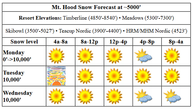
The transition starts today after a cold start – temps were in the low 20s on the slopes as I was writing this. The free air freezing level rises from 0′ this morning to around 10,000′ this afternoon with temps rising from the 20s to the mid 40s. Wind will be N 10 in the morning, NW 20 in the afternoon, and light NW overnight.
Liking this forecast?
Another warm and sunny day is forecast on Tuesday. A few high clouds in the morning give us a shot at a pretty sunrise. After that, the sky clears. The free air freezing level (FAF) will be 10,000′ all day. Temps max out in the upper 40s. Despite the warmth, radiational cooling overnight will allow the snow to set up – it will be a firm start. Wind: light NW in the morning, NW 15 in the afternoon, and NNW 10 overnight. Warm, sunny, not-very-breezy weather continues on Wednesday with high temps pushing towards 50F on the slopes.
Something different this way comes on Thursday: a cold front from the NW. Moisture will be limited; models are just giving us a trace or perhaps an inch of snow. In the morning, the snow level will be 10,000′, but it will crash to 1000-1500′ with the passage of the system in the afternoon. It’ll be accompanied by increasing WNW wind: W 20 to start, WNW 30-40 in the afternoon, and NW 10 overnight. Dry, cold weather sticks around for Friday and Saturday. Models suggest we’ll be back to warmer weather on Sunday. Models show little sign of any precip before the following weekend. Break out the sunscreen, cuz you’re going to need it! Have a great day on the slopes!
Was that helpful? I knew it was! Guess what? All of this crucial work – from your personal wind and snow reports to the invaluable TATAS updates – is made possible by my relentless efforts. Maintaining this labor of love isn’t easy. Each daily forecast takes hours. Website hosting, weather model access, and back-end admin work takes time and money. That’s where you come in.
YOUR CONTRIBUTION MAKES A DIFFERENCE
- SUPPORT ACCURATE, HYPER-LOCAL WEATHER FORECASTING
- ENABLE ACCESS FOR ALL, EVEN THOSE WITH LESS MEANS
- SUPPORT A COOL HUMAN WHO WORKS HARD SO YOU CAN PLAY
Take a moment to click one of the buttons below. Donate $19.99 or more (how much does this forecast enhance your life?) and get the email in your inbox. Whether it’s a renewing subscription (auto-renew) or a one-time donation, every contribution makes a real difference. Help me keep this labor of love alive, so we can all continue playing, commuting, and living in the Gorge with peace of mind and the best weather forecasts possible. Thank you!


Hood River, Oregon 97031


GORGE WIND FORECAST

Hi friends! It’s a fun day in weather forecasting land – the UW Atmospheric Sciences website is down, so I’m relying on all the backup website and backup models. So now we all see what happens when the high res models go down… way less accuracy and detail! Anyway, the day starts with pressures of 30.59/30.58/30.54 for a moderate onshore gradient. Models suggest gradients go flat for calm wind midday and turn weakly onshore this afternoon for a shot at westerlies at 12-15mph from Stevenson to Swell. River flow over the last 24 hours was 111-149kcfs, river temp is 43.24 degrees, and high temp forecast is 43F and mostly clear by the afternoon.
Tuesday bring light easterlies. Not much to write home about here. High temp: 43F with Nothing in the morning and sun in the afternoon. Stronger easterlies are forecast on Wednesday – 30mph near Iwash and 25mph near Stevenson. High temp: 41F with sun in the windy zone. Offshore high pressure returns on Thursday with a powerful (but dry) cold front swinging through. Models have us with west wind right off the bat. There’s still a lot of uncertainty how strong the westerlies will be, but I think it’s fair to say we’ll see at least 21-24mph at the Hatch (where it will be quite gusty) with a good shot at slightly stronger wind at Rufus. That’s all for now. Cross your fingers the models come back online soon!
BARE BONES HOOD RIVER WEATHER FORECAST
Nothing this morning gives way to partly cloudy sky later. Temps start in the upper 20s and rise to the low 40s. Light and variable wind. No rainbows. Tuesday will be Nothing then mostly clear. Temps start in the low 30s and rise to the low 40s. Light easterlies. No rainbows. Wednesday will be Nothing then partly Nothing. Temps start near 30 and rise to the low 40s. Easterlies. No rainbows.
TEMIRA’S AWESOME TRAVEL ADVISORY SERVICE (DETAILED GORGE WEATHER FORECAST)

Good morning, neighbors! This morning marks the first hard frost of the year at my place down in the lowlands of Hood River. I will have to scrape my windshield for the first time this winter unless one of you comes and does it for me. We should see a few more of these frosty mornings coming up, especially after Thursday; models drag in a couple days of cooler air. Nothing like what they originally forecast (regression to the mean!) but still cooler on average than we’ve seen so far.
TODAY
Speaking of… Glenwood’s our winner this morning with a low temp of 17 degrees. Everyone else is above 20 degrees. Chilly temps like this signal plenty of clear sky above the Nothing. Models do think the Nothing will burn off today and leave us with scattered high clouds and plenty of sun. Highs climb to the low 40s in the lowlands. We’ll see light westerlies today peaking at 15mph near Hood River.
Note: the UW website is down this morning, which leaves me without a high-res wind model for the Gorge. Sad. Makes it real hard to put out an accurate and precise forecast.
TUESDAY-WEDNESDAY
Tuesday looks a bit warmer to start thanks to much warmer air aloft. Still, the day begins with a Nothing down low and clear sky above it. Once again, models insist the Nothing will (mostly) burn off and leave us a with a few high clouds. If the timing is right, we’ll get a nice sunset out of that. Wind: light easterly. High temp: low 40s. Similar weather is forecast on Wednesday with the following changes from Tuesday: bigger, longer-lasting Nothing, easterlies at 25-35mph in the usual spots, and highs near 40F.
THURSDAY AND BEYOND
A cold front swings through on Thursday morning. Not much moisture accompanies it – probably just a trace to a tenth of an inch, and only west of Mosier. Accompanying this system will be west wind at 20-30mph. Also in the cards: much colder air. Everyone east of Hood River should be clear and chilly Thursday night into Friday morning. Colder, but not frigid, weather is forecast Friday and Saturday. Next chance of significant precip doesn’t show up in the models until the following weekend. K, I’m moving on from this forecasting. Doing it without all the models is not my favorite thing. Y’all have a great day today! Safe travels. -TATAS
HEY! DON’T STOP READING! Is this community-focused forecast helpful to you? It sure it! It takes me a couple hours a day to write. Please jump in a contribute to keep it going. Venmo: @thegorgeismygym PayPal: [email protected] USPS: Temira / PO Box 841 / Hood River, Oregon 97031 You can test out the forecast subscription for a few days for free by clicking this link: https://subscribepage.io/YhevGc


Leave a Reply