MT. HOOD SNOW FORECAST

Hey skiers and snowboarders! A couple stormy days are on tap for Mt. Hood, and then we slither on back into a stretch of warm, sunny weather. Sometime for everyone in this report, including the potential for shutdown-strength wind.
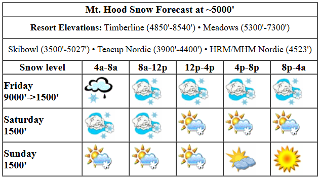
Wind speeds are already ramping up on this fine Friday morning: top of MHX at Meadows is reading 39g54 from 265 degrees. That’s going to shut down some lifts for sure. A weather system slams into the mountain around sunrise or a bit after. While this could (unlikely) start as mixed precip, it’ll transition to snow before you can find your Hefty bag. The snow level plummets from 9000′ in the morning to 2000′ in the afternoon and crashes down to 1000-1500′ overnight. Temps fall from 40ish degrees to the low 20s. About 0.6” water equivalent (WE) is forecast during the day for 4-6” increasingly dry powder. Overnight, another 0.2” to 0.3” WE is in the cards for 2-4” additional blower pow. Wind is going to be problematic: W 40 early, WNW 40-45 in the afternoon and evening, and NW 30 overnight. To put this into perspective, I’ve seen that kind of forecast shut down Meadows and T-Line before. Definitely check the websites before heading up, especially this evening. Also worth noting: there’s not a ton of moisture around, but this wind direction and strength will rip every possible snowflake out of what moisture is here. We could exceed those totals by 20-30% if we’re very lucky.
Liking this forecast?
Models hint at flurries and sunbreaks on Saturday, and they also have strong wind. The snow level will be 1000-1500′ all day. Snowfall will be entirely orographic (terrain-based), and really depends on whether there’s enough moisture to build clouds at ski resort elevations. For now, let’s just call it intermittent flurries and sunbreaks and not be surprise if the mountain ends up stuck in an orographic cloud with light snowfall all day. Wind: NW 30 in the morning, NW 25-30 in the afternoon, and NW 20-25 overnight. Once again, that morning wind forecast is problematic and could affect lift ops.
A similar pattern is in the cards for Sunday: a few flurries and some sun. The snow level will be 1000-1500′ all day. Overnight, the free air freezing level drops to 0′ under clear sky. If we do see snowfall, it’ll just be a trace. Wind: NW 20-25 in the morning, NW 10 in the afternoon, and N 10 after midnight.
Next up: a transition away from storms and back to sun. Monday starts cold and clear (blue wax day!) and ends finishes up sunny and just above freezing. The rest of the week contains a fair number of sunny, warm days with a transitioning snow surface. Pack sunscreen, snacks, and your work-from-ski-resort setup. Have a great day on the snow!
Was that helpful? I knew it was! Guess what? All of this crucial work – from your personal wind and snow reports to the invaluable TATAS updates – is made possible by my relentless efforts. Maintaining this labor of love isn’t easy. Each daily forecast takes hours. Website hosting, weather model access, and back-end admin work takes time and money. That’s where you come in.
YOUR CONTRIBUTION MAKES A DIFFERENCE
- SUPPORT ACCURATE, HYPER-LOCAL WEATHER FORECASTING
- ENABLE ACCESS FOR ALL, EVEN THOSE WITH LESS MEANS
- SUPPORT A COOL HUMAN WHO WORKS HARD SO YOU CAN PLAY
Take a moment to click one of the buttons below. Donate $19.99 or more (how much does this forecast enhance your life?) and get the email in your inbox. Whether it’s a renewing subscription (auto-renew) or a one-time donation, every contribution makes a real difference. Help me keep this labor of love alive, so we can all continue playing, commuting, and living in the Gorge with peace of mind and the best weather forecasts possible. Thank you!


Hood River, Oregon 97031


GORGE WIND FORECAST

Hi friends! Looks like a couple good west wind days on tap thanks to strong offshore high pressure. If that’s not enough, models are hinting at an extended period of easterlies next week. But first, let’s start with today, Friday. A cold front zips through, and offshore high pressure surges into place behind it. Expect rain to extend all the way east, almost to Idaho, this morning with showers to Rowena this afternoon. Even with the rain, models suggest a period of gusty 24-27 from Stevenson to Hood River mid-morning with 18-22 out east. Stronger wind kicks in this afternoon: 28-32 from Avery to Arlington, probably strongest at Arlington early and then settling in for the long haul near Rufus. In theory, this is the “right direction” setup for Rufus and The Wall. Let’s test that out today, shall we? River flow over the last 24 hours was 96-162kcfs, river temp is 43.70F, and high temp forecast is 47F with drizzle and partly cloudy sky in the west and full-on sun out east.
Saturday holds on to that strong offshore high pressure. This setup is one you’d expect in June, not January (so maybe it’s Junuary?). The day starts with 20-23 out east and 14-17 in the west. Give it a couple hours to wake up, and we’ll have 23-26 from Stevenson to Arlington. In the afternoon, the wind is likely to drop to 17-20 out east and 20-23 west of Maryhill. There are some mixed signals about where the cloud line will set up. Get east of it for the most consistent wind. High temp: 44F with clouds in the west and sun to the east. Sunday starts with lingering westerlies in the low teens, but high pressure shifts inland and turns the wind calm in the afternoon. High temp: 45F with slowly clearing sky. We return to the east-wind inversion pattern starting on Monday and hang on to it for at least a few days. Not a bad stretch of wind, eh? Have a great time out there!
BARE BONES HOOD RIVER FORECAST
Clouds and heavy rain this morning give way to showers and sunbreaks this afternoon. Temps start in the mid 30s and rise to the mid 40s. Light easterlies early. Moderately strong westerlies later. 99.9% chance of rainbows. Saturday will be partly to mostly cloudy. Temps start in the upper 30s and rise to the mid 40s. Moderately strong to strong westerlies. 0.1% chance of rainbows. Sunday will be cloudy in the morning and mostly clear in the evening. Temps start in the upper 30s and rise to the mid 40s. Light westerlies early. Calm wind later. No rainbows.
TEMIRA’S AWESOME TRAVEL ADVISORY SERVICE (GORGE WEATHER)

Good morning, neighbors! It’s the first Friday of the rest of your life, yay! This one’s kicking off with freezing rain for some of you, rainbows for most of you, and wind for all of you. Guess what else we’ll have? SUN! Sun continues for many on Saturday and Sunday before we collapse back into an inverted Nothing pattern on Monday and stay there for a while.
TODAY
Yeah, sorry about the ice. Today’s system comes in with temps at 40 degrees at 5000′ and temps below freezing in Trout Lake, Glenwood, Parkdale, Middle Mountain, York Hill, Sevenmile Hill, Dufur, High Prairie, Appleton, and Snowden. When this heavy rain hits, you’re going to see a short icy smackdown before very strong west wind comes in and warms you up. Sorry also for the wind. I just felt like making it windy today so I could go SUP foiling. Down in the lowlands: heavy rain starting around sunrise (whenever that is) as far east as Hood River, moderate rain to The Dalles, and light rain all the way east past the Arlington Triangle (which might get wet today for once). In the afternoon, rain retreats from the desert and hangs out west of Rowena. Between Stevenson and Rowena: lots of rainbows. Between Stevenson and Arlington: lots of wind – 25-30mph out of the west most places with more possible up in the hills; the mountains are expecting NW 40mph, snow, and a rapidly dropping snow level. Expect very slick conditions up there as the roads go from warm and wet (like my pussy) to cold and icy (like, well, I don’t want to accuse anyone’s heart of that, but sadly, some hearts are that way).
SATURDAY
Overnight tonight, the sky clears in many places. Before it does, a little snow, a trace to an inch, is possible in areas above 1000′ and west of Mosier. Roads freeze almost everywhere, especially where there’s any sign of stars. “Sign of stars” is different than star signs, which have exactly zero correlation with personality when examined scientifically. That said, I’m a typical Capricorn: I like to eat goats and goat cheese. Expect black ice all over the place to start Saturday. Sun shines all day in the desert on Saturday, and the west sees partly cloudy to mostly cloudy sky. Haven’t had enough rain? Head west of Cascade Locks for all-day drizzle. Temps max out in the mid 40s. West wind will be 20-25mph pretty much all day west of John Day Dam with 15-20 east of there to Arlington.
SUNDAY
Another freezing night is in the cards Saturday into Sunday as temps at 5000′ drop to -6C, the sky clears, and light west wind sticks around. Watch out for icy roads. It’ll be a great evening for cuddling and sleeping over and waiting to leave until the black ice goes the way of the dodo. Sunday starts cloudy in the west and sunny to the east with a few random flurries possible near Dufur. As the day progresses, more and more blue sky appears. High temps: mid 40s in the lowlands. Freezing level: 1000-1500′. Wind: west 15mph in the morning and calm in the afternoon.
MONDAY AND BEYOND
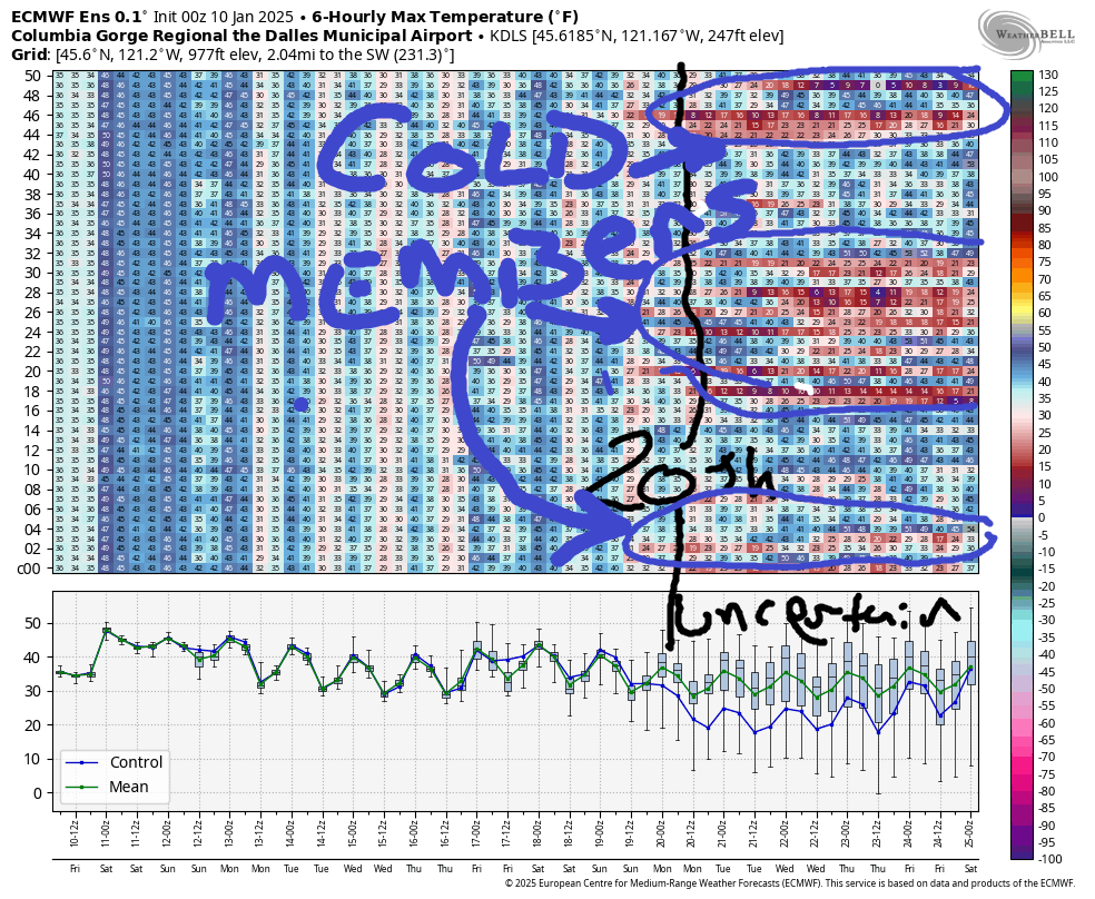
The Nothing returns on Monday and sticks around for a while. So do the easterlies. Head up to the mountains or west to Stevenson and beyond for sunshine. Looking way out into the future, about 30% of the ensemble members still insist on some sort of colder arctic air situation starting the 20th. We call these the cold members; over time, due to being extremely cold, they are likely to experience shrinkage. In the statistical world, that’s known as “regression to the mean”. The rest of the ensemble members basically continue with WYSIWYG starting Monday. Speaking of, that’s all you get today. Safe travels. -TATAS
HEY! DON’T STOP READING! Is this community-focused forecast helpful to you? It sure it! It takes me a couple hours a day to write. Please jump in a contribute to keep it going. Venmo: @thegorgeismygym PayPal: twomirrors@gmail.com USPS: Temira / PO Box 841 / Hood River, Oregon 97031 You can test out the forecast subscription for a few days for free by clicking this link: https://subscribepage.io/YhevGc


