MT HOOD SNOW FORECAST

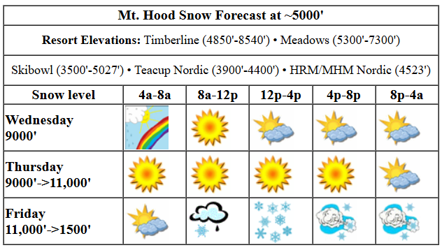
Hey skiers and snowboarders! If you’ve been wanting a day of sun on the slopes, today is your day! No, wait, tomorrow is your day! Actually, there’s plenty of sun in the forecast. Next chance for snow is on Friday… Wondering about the snow surface? It’s frozen granular right now. That means it’ll be hard, fast, and noisy in the morning, but could soften up to corn in the afternoon in the sunny areas. Wax today: red or red/violet mix, if waxing is your thing.
Wednesday’s kicking off with. Some high clouds move in later, and they dissipate overnight. Today’s free air freezing level will be around 9000′ with high temps around 40F at 5000′. Wind: NW 15 all day and E 15 overnight.
Thursday looks sunny all day and partly cloudy overnight. Snow: frozen granular becoming corn. The free air freezing level rises from 9000′ in the morning to 11,000′ in the afternoon. Sunscreen: required. Wind: E 15 in the morning, light/variable in the afternoon, and WSW 35 overnight.
Liking this forecast?
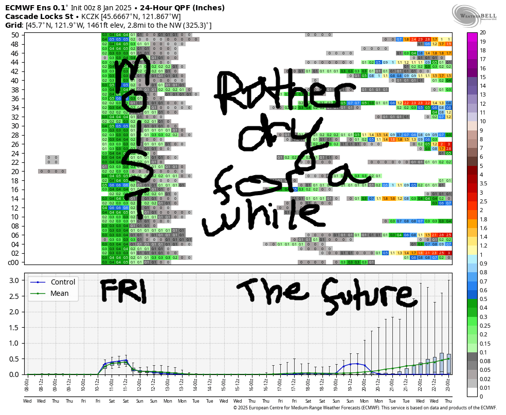
If you guess that the increasing wind indicated an incoming weather system, you were right! A cold front arrives Friday morning. Early in the day, the snow level will be 11,000′, but it quickly falls to 5500′ with the arrival of this system and keeps dropping. Overnight, the snow level lands at 1500′. We could see a little mixed precip at the start, but it will very quickly switch to snow. About 0.3” water equivalent (WE) is forecast by 4pm for 2-3” of increasingly dry snow. Overnight, another 0.2” we is forecast for a couple inches more. If we do get 4-6” of snow, that’ll be enough to refresh the groom. Fingers crossed! Wind will be WSW 35, early, W 35 mid-morning, and NW 30-40 from afternoon on through the night. That NW direction can be tricky, and despite the seemingly low speed, it could take out a lift or two.
Models hint at some orographic snowfall on Saturday thanks to the wind, but they also call for mostly clear sky. Call it flurries with an inch or two possible. The snow level will be around 1000-1500′. Wind: NW 30-40 all day and all night. Again, that could affect lifts. Dry, sunny, cold weather is forecast on Sunday with temps near 20 and the freezing level around 1000′. Breezy conditions continue. Let’s leave it there for now and all cross our fingers for half a foot of snow from Friday’s system. See you on the groom!
Was that helpful? I knew it was! Guess what? All of this crucial work – from your personal wind and snow reports to the invaluable TATAS updates – is made possible by my relentless efforts. Maintaining this labor of love isn’t easy. Each daily forecast takes hours. Website hosting, weather model access, and back-end admin work takes time and money. That’s where you come in.
YOUR CONTRIBUTION MAKES A DIFFERENCE
- SUPPORT ACCURATE, HYPER-LOCAL WEATHER FORECASTING
- ENABLE ACCESS FOR ALL, EVEN THOSE WITH LESS MEANS
- SUPPORT A COOL HUMAN WHO WORKS HARD SO YOU CAN PLAY
Take a moment to click one of the buttons below. Donate $19.99 or more (how much does this forecast enhance your life?) and get the email in your inbox. Whether it’s a renewing subscription (auto-renew) or a one-time donation, every contribution makes a real difference. Help me keep this labor of love alive, so we can all continue playing, commuting, and living in the Gorge with peace of mind and the best weather forecasts possible. Thank you!


Hood River, Oregon 97031


GORGE WIND FORECAST

Hi friends! It’s looking increasingly likely that we’ll have a two to three day stretch of west wind Friday through Sunday. That’ll be preceded by a plenty-strong easterly day on Thursday. Hopefully your summer paddling/winging/etc fitness is still on board! Wednesday, today, is the light one. The day starts with E 26mph at Iwash (Rooster) Rock and goes calm midday. Stevenson languishes at less than 10mph until the afternoon, when it picks up to 20-25mph. Elsewhere: not much at all. River flow over the last 24 hours was 131-173kcfs, river temp is 43.88F, and high temp forecast is 46F and mostly clear.
Thursday brings strong east wind: 40-50mph at Iwash and 35mph at Stevenson. The wind holds all day. High temp: 40F with clear sky in the morning and a few high clouds in the afternoon in the windy zones. A strong system swings in from the NW on Friday, and even stronger high pressure builds offshore. Models suggest an east wind start quickly followed by a switch to westerlies. For now, let’s call it 22-25 from Stevenson to Swell and also from Avery to Rufus (lighter from Hood River to Doug’s), but reality may beat this thanks to 1036mb offshore. Saturday: W 21-24 centered on Swell. Sunday, probably continued west wind thanks to very strong offshore high pressure. My fingers are all crossed for these westerlies. Hope to see you out there!
BARE BONES HOOD RIVER FORECAST
Nothing this morning. Mostly clear later. Temps start in the upper 30s and rise to the mid 40s. Light easterlies, calm midday, light easterlies later. No rainbows. Thursday will be Nothing. Temps start in the low 30s and rise to the mid 30s. Easterlies. No rainbows. Friday will be Nothing then rainy then partly cloudy. Temps start in the low-mid 30s and rise to the mid 40s. Light easterlies early. Moderately strong to strong westerlies later. 99% chance of rainbows.
TEMIRA’S AWESOME TRAVEL ADVISORY SERVICE (TATAS)

Good morning, neighbors! Know that thing bright, blazing thing that you’ve been seeing in the sky recently? It’ll be back for part of today, and it’ll return at times this weekend. Next chance for exciting weather, freezing precip of some random sort, is early Friday for a few select folks…
But first, today’s most important news: IT’S MY BIRTHDAY! If you want to send cards, sunny weather, or dick drawings (NOT DICK PICKS), my address is in the last paragraph. You can also leave dick drawings in the Facebook comments.
Weather for my b-day will be Nothing to start and sunny to finish. All-day sun and 40-something temps will be found in the mountains thanks to a settled-in inversion. Down here, temps rise to 40ish. East wind at Cock Rock will be 25mph this morning and will turn calm this afternoon. Stevenson will be 5-10mph most of the day and will rise to 25mph in the afternoon when Cock Rock winds go limp and soft.
Nothing settles in on Thursday. Foggy, misty goo leaves us with a sub-freezing zone of slick roads in the middle elevations. Above that, you’ll find sun in the morning and a few high clouds in the afternoon. Below it: glooooooooom. Head west to the windy zones for sunshine, and hold on to your hat and merkin. Iwash (dick) Rock sustains 50mph easterlies all day. Stevenson will be in the 30-40mph range all day.
Overnight, a weather system approaches like a big fluffy dog sneaking into bed with you in the middle of the night. Rain starts up around sunrise and extends as far east as Celilo. East of Hood River, the rain ends by noon. West of Hood River, drizzle continues through the weekend (sorry, Cascade Locks). Accompanying this weather system will be west wind. JOHNNIES DELIGHT! After a 25mph east wind start near Iwash (pen*s) Rock, the wind turns westerly at 25mph most places between Stevenson and Bob’s Texas T-Bone (the location formerly known as Rufus). Thanks to the westerlies, temps rise to the mid-40s in the lowlands. Overnight, the snow level falls to 1500′ or so with partly cloudy sky. This leaves us with icy roads. A few select areas – Parkdale, Trout Lake, Mill A – could pick up a trace to an inch of snow. Black ice is more the concern than snow Friday night into Saturday – with clear sky in the cards, all locations could see the roads refreeze.
For folks east of Viento, the weekend should be dry, sunny, and cool with west wind blasting away the clouds. Watch out for overexcited wind johnnies (yes, they do their thing in the winter too) zipping around hooting and hollering like coyotes playing with the tennis ball they stole from your dog. Safe travels. -TATAS
HEY! DON’T STOP READING! Is this community-focused forecast helpful to you? It sure it! It takes me a couple hours a day to write. Please jump in a contribute to keep it going. Venmo: @thegorgeismygym PayPal: [email protected] USPS: Temira / PO Box 841 / Hood River, Oregon 97031 You can test out the forecast subscription for a few days for free by clicking this link: https://subscribepage.io/YhevGc


Leave a Reply