

MT HOOD SNOW FORECAST

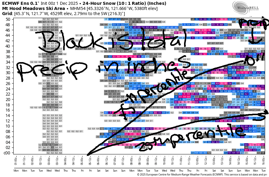
Hey skiers and snowboarders! The ski season waiting game continues, and we still have near-zero clarity on the p-type and amounts through the middle of next week. The GFS is trending slightly warmer, but it still hints at snow. The Euro ensemble is unapologetically too warm for snow. Looking at this a different way… the Mt Hood snow forecast via the Euro ensembles through next Monday morning has 2.5” of snow at the 10th percentile and 46” of snow at the 90th percentile. That’s a HUGE range. In an interesting twist, despite the GFS deterministic being quite cold, the GFS ensembles have 0.2” to 11” of snow in that same time frame.
My best guess: it’s probably going to be too warm given the incoming atmospheric rivers Thursday through Saturday and again next week Tuesday into Wednesday. You can see this in the snow/precip image – lots of precip (5-10”), but most ensemble members don’t have a ton of snow with all that moisture.
Lets look at some deets: Monday looks warm and partly cloudy. The free air freezing level will be 10,000′ in the morning and 8500′ in the afternoon. It falls to 4000′ after midnight. Wind: Light NW in the morning slowly building to NW 35 after midnight. A little bit of moisture accompanies that NW wind on Tuesday, which could give us an inch or so of snow. Maybe two inches if we get really lucky! Snow starts around 4am and finishes up in the afternoon. Snow level: 4000′ all day rising to 4500′ after midnight. Wind: NW 35 in the morning, NNW 15 in the afternoon, and light northerly overnight.
Wednesday starts clear and turns cloudy. Freezing level: 4500′ rising to 5500′ after midnight. Wind: light northerly becoming W 15 then N 10. Tuesday starts cloudy and turns rainy. Drizzle prior to sunset gives way to moderately heavy rain overnight with the snow level rising to 9500′. We start to see disagreement on temps as we move deeper into the future. Where do we see agreement? Around the wetness: it look pretty darn wet (but not torrential) Friday into Saturday. We may see a break for a day or two. Uncertainty rises as we move into Tuesday, but there are some indications of another round of heavy precipitation. Once again, the Euro is warm and the GFS is cooler, but I suspect that system will be too warm. Patience, everyone! We’ll shred together soon!
Was that helpful? I knew it was! Guess what? All of this crucial work – from your personal wind and snow reports to the invaluable TATAS updates – is made possible by my relentless efforts. Maintaining this labor of love isn’t easy. Each daily forecast takes hours. Website hosting, weather model access, and back-end admin work takes time and money. That’s where you come in.
YOUR CONTRIBUTION MAKES A DIFFERENCE
- SUPPORT ACCURATE, HYPER-LOCAL WEATHER FORECASTING
- ENABLE ACCESS FOR ALL, EVEN THOSE WITH LESS MEANS
- SUPPORT A COOL HUMAN WHO WORKS HARD SO YOU CAN PLAY
Take a moment to click one of the buttons below. Donate $19.99 or more (how much does this forecast enhance your life?) and get the email in your inbox. Whether it’s a renewing subscription (auto-renew) or a one-time donation, every contribution makes a real difference. Help me keep this labor of love alive, so we can all continue playing, commuting, and living in the Gorge with peace of mind and the best weather forecasts possible. Thank you!


Hood River, Oregon 97031


GORGE WIND FORECAST
If you’re still seeing yesterday’s and it’s after 9am, try opening this in an incognito window
today’s gorge wind forecast
Hi friends! Gorge wind bounces around between east and west for the next few days. Models continue to hint at stronger westerlies on Friday or Saturday, which you may be able to count on because I’m heading out on retreat Friday! Murphy’s Law!
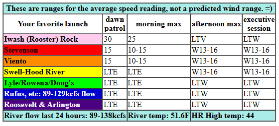
Monday kicks off with easterlies at 30mph near Iwash and 20mph near Stevenson with 15mph at Viento. You’ll get a couple hours of this. By late morning or early afternoon, the wind shuts down. After 1pm, it switches to westerly at 13-16mph from Stevenson to the Hatchery with less wind to the east. River flow over the last 24 hours was 89-138kcfs, river temp is 51.6F, and high temp forecast is 44F, which puts us under 100F total for water + air. Be safe out there!
RIVER FLOW FOR SITES BETWEEN AVERY (EAST OF THE DALLES) AND RUFUS: CLICK HERE FOR JOHN DAY DAM FLOW.
RIVER FLOW FOR SITES BETWEEN STEVENSON AND DOUG’S BEACH (WEST OF THE DALLES): CLICK HERE FOR THE DALLES DAM FLOW

tomorrow’s gorge wind forecast
Tuesday starts with westerlies in the single digits west of The Dalles and mid teens from Avery to Arlington. After a brief period of 20-25mph near Rufus, the wind drops out east. We’re left with 16-19mph or a touch more from Stevenson to The Dalles. High temp: 49F with drizzle west of The Dalles in the morning and partly cloudy sky later.
extended Gorge wind forecast
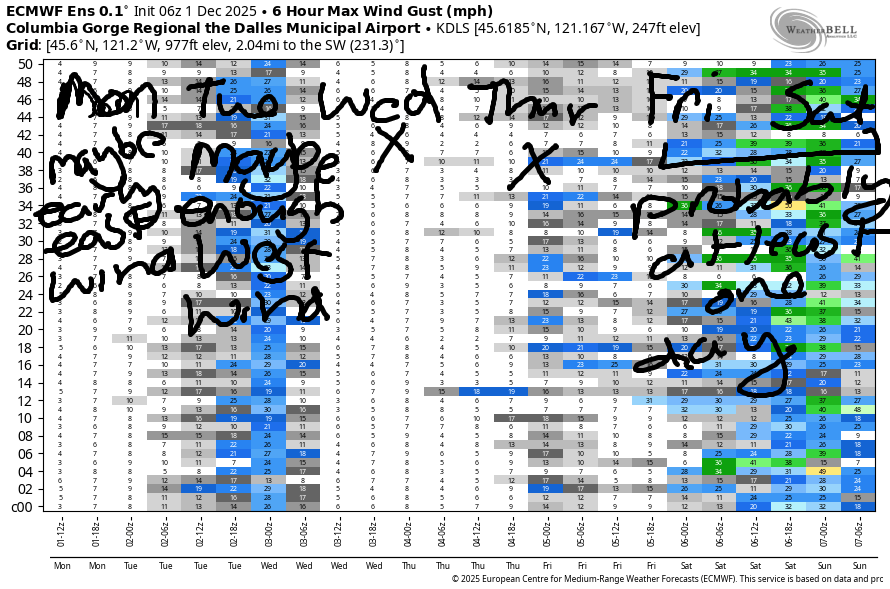
Easterlies return on Wednesday: 20-25mph at Iwash (rooster) Rock and 15-20mph at Stevenson. In the afternoon, the wind goes calm. Thursday sees a weather system approaching and then landing. This gives us 19-22mph or so west of the Hatch and east of Rufus. High temp: 48F. A low is forecast to move inland on Friday (or Saturday) with high pressure building behind in a very active weather pattern. Ensembles agree on very strong wind aloft, but they’re not agreeing yet on how strong the wind will be at the surface. We’ll keep watching it. For now, I’d say there’s a bout a 70% chance of enough wind for foil sports and 15% chance of enough wind for fin sports. Fingers crossed!
BARE BONES HOOD RIVER WEATHER FORECAST
Nothing plus other clouds this morning. Partly high overcast later. Temps start in the low-mid 30s and rise to the mid 40s. Light easterlies early. Light to moderate westerlies later. No rainbows. Tuesday will be cloudy with light drizzle then partly cloudy. Temps start in the mid 30s and rise to the upper 40s. Moderate westerlies. 89% chance of rainbows. Wednesday will be partly Nothing then partly high cloudy. Temps start in the low-mid 30s and rise to the mid 40s. Light easterlies then light westerlies. No rainbows.
TEMIRA’S AWESOME TRAVEL ADVISORY SERVICE
HYPERLOCAL WEATHER FORECAST FOR THE COLUMBIA GORGE
THE DALLES, HOOD RIVER, WHITE SALMON, TROUT LAKE, STEVENSON, CASCADE LOCKS, PARKDALE, ODELL, HUSUM, BZ, MILL A, WILLARD, GOLDENDALE, RUFUS, ARLINGTON, boardman
Good morning, neighbors! It’s a chilly morning here in the Gorge, but don’t you worry – snow isn’t in the forecast any times soon. Know what is in the forecast? The potential for lots of rain! Looking around the Gorge this morning, we haven’t seen any ¡ce on the roads, but I suspect there are some frosty and slippery spots in areas that tend to be shady and damp. Do be careful out there!
Glenwood this morning
Glenwood had a low temp this morning of 22 degrees, which has everyone sitting in rocking chairs in front of the fire reading Catch-22. Catch-22 has some parallels with the now – for the 25th Amendment to be implemented, one’s most trusted and powerful advisors must advocate for it, but those same people risk losing all the power they’ve worked for if they advocate for the 25th amendment, so…
Today’s Gorge wind forecast
Speaking of the number 25, that was the low temp in Centerville this morning. Elsewhere in the region, most folks away from the river were around 30F, and most folks along the river were above freezing. Speaking of freezing, you will freeze your ass off (or other body parts) if you head to Iwash (RELEASE THE PEDO-FILES) Rock this morning: easterlies are 30mph there and 20mph in Stevenson. The wind shuts off midday and turns around to west 15mph, but just west of Mosier. Highs today will be in the mid 40s (brrrrrrr) under partly high overcast afternoon sky.
Overnight, we’ll have a little drizzle east of Rufus and west of Mosier. I can’t rule out snowflakes out near the Tri-Cities, but again, that ain’t my zone to predict.
Tuesday’s Gorge weather forecast
Tuesday morning closer to home, we’ll have drizzle as far east as Hood River and partly cloudy sky to the east. Drizzle ends by noon or so, which is great for everyone planning a nooner. Morning temps will be in the mid-upper 30s, and afternoon reaches 50F or so between Stevenson and The Dalles. Wind will be westerlies at 15-20mph between Stevenson and the Arlington Triangle, with the wind lessening east of The Dalles in the afternoon.
Wednesday’s Gorge weather forecast
Overnight into Wednesday, the sky partially clears, and the wind switches to easterly. This allows temp to drop below freezing away from the Nch’i Wana and into the mid 30s near it. Clouds increases during the day ahead of the next weather system. East wind starts at 20mph in the usual spots and turns calm in the afternoon. Next up: rain!
Extended Gorge weather forecast
Starting midday Thursday, rain arrives. While it starts as drizzle, the intensity increases into the evening. Friday through Sunday look quite wet west of The Dalles with intermittent showers/rain to the east. Uncertainty increases starting Monday, but there are at least some hints of very, very wet conditions Monday into Wednesday. We’ll see how this plays out. I vote for this scenario because I’ll be on retreat, and rainy retreats are the best.
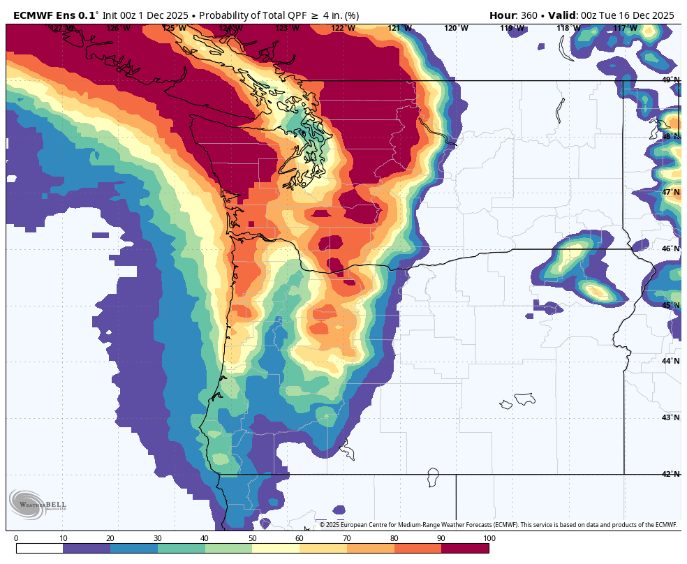
Just how wet are we talking? Through next Tuesday for the Cascades, models have 100% chance of 2” inches of rain, 70-90% chance of 4+” of moisture, and 20-30% chance of 8+” of moisture. There’s even a 10-20% chance of 15+” of moisture for Mt. Adams! It’s harder to figure out the percentages for the lowlands due to challenges associated with model resolution. Let’s just say that for this time period, the chances of areas west of The Dalles receiving 4+” of rain or more are non-zero. WET! Safe travels. -TATAS
HEY! DON’T STOP READING! Is this community-focused forecast helpful to you? It sure is! It takes me a couple hours a day to write. Please join your friends and neighbors in contributing to keep it going. Venmo: @thegorgeismygym PayPal: twomirrors@gmail.com USPS: Temira / PO Box 841 / Hood River, Oregon 97031 You can test out the forecast subscription for a few days for free by signing up below. Easy! Do it!
JONES BEACH, SAUVIE ISLAND, & COAST FORECAST
ON WINTER VACATION UNLESS DESPERATELY NEEDED.
