
Thank you for using this forecast. Like it? Find it useful? Support it (and me!) by sending some cash my way. What’s it cost to support me and get the email version? Not $99 a year. Nope. Not $49. Just $19.99 or more gets you a year. People are added to this list on Thursday and Sunday. My day job is crisis mental health, and I don’t have time on other days. Thanks for your patience! Click below to contribute. Thank you!!
 |
|
 |
The Forecast
| Your favorite beach | Dawn Patrol |
9am- 11:30a |
11:30a- 3pm |
3pm- dusk |
|
|---|---|---|---|---|---|
| Rooster Rock | E 10-15 | E 10-15 | E10 | calm | |
| Steven’s Locks | E 10-15 | E 10-15 | E10 | calm | |
| Swell-Hood River | calm | calm | calm | calm | |
| Lyle to Doug’s | calm | calm | calm | calm | |
| Rufus, etc. | calm | calm | calm | calm | |
| Roosevelt & Arlington | calm | calm | calm | calm | |
Gorge Wind Forecast
It’s a calm and quiet Sunday morning in the Gorge, but if you head to Mosier, you’ll find all the hustle and bustle that comes with a swap meet. This one benefits the Mosier Fire Department. Sellers were welcome at 7am. Buyers are welcome at 8am. Mosier Fest itself starts at noon. As for the wind, it’ll be limited to easterlies midday today between Rooster and Viento. We’ll switch back to westerlies tomorrow, but there sure are a lot of dynamics going on to impact the wind quality. We’ll dig into that below.
For Sunday, we’ve got high pressure over the Northwest and a heat low over the metro area, generally speaking. This gives us a weak offshore gradient of 0.05 through the Gorge. Those easterlies peak at 15-20 between Rooster and Viento for a few hours this morning. By the afternoon, they’ll drop to 10mph, and by late afternoon, the wind should be nearly calm or calm all the way from Stevenson to Arlington. River flow readings are 150-162kcfs, river temp is 70F, and high temp forecast is 93F.
A low sitting off the northern Cali coast moves close enough on Monday to drive some cooler air into the west side of the PNW. The heat low shifts east, and gradients turn onshore. Unfortunately, this is not the cooldown you were looking for – we want offshore high pressure. Why? Well, this low will turn upper flow southerly, start to drive moisture into the area, and destabilize the atmosphere. Not only does that make the wind gusty and unreliable, it makes the forecast less accurate! So, the day starts with 12-16ish from Viento to Swell (or calm wind if you look at the 4/3 model!). The wind builds to 17-21 from Stevenson to Mosier midday. Afternoon: if instability doesn’t mess things up, we could see gusty 22-25 from Stevenson to Doug’s with E 5-10 in the eastern Gorge. Moral of the story: you’ll have the best results midday before destabilization gets going!
All sorts of interesting things happen on Tuesday. We’ll have a higher chance of thunder than on Monday, and we also, according to the GFS, have a chance at showers all day long. That doesn’t bode well for the wind! If we limit our look to the 12k wind model, we see dawn patrol at 24-27 from Stevenson to Mosier. That’s the peak for the day. The wind quickly drops to gusty 21-24 from Stevenson to Mosier with light wind (and hot weather) to the east. Models hint at significant destabilization Tuesday afternoon with the wind potentially dropping to nothing west of The Dalles and picking up (but subject to thunder) to the east. In other words… not a very reliable day!
There’s a hint of better results on Wednesday as that low opens up into a trough. But then it reforms Thursday and Friday leaving us with the dreaded Upper Level Low offshore. That said, there’s a ton of model spread from Tuesday into the future, so let’s hold off and see what happens. Have a great day today!
Jones, Sauvie’s, Coast
Coast forecast (north/central/south, waves). Swell forecast provided by NWS. Wind direction northerly unless otherwise noted. Sunday: 15-20/SW10/S10, NW swell 4′ @ 7. Monday: SW10/S15/S10, NW 5′ @ 9. Tuesday: SW10/W5/S10, NW 6′ @ 9. Jones Sunday: LTW. Monday: 25-28. Tuesday: 20-23. Sauvie’s Sunday: 10-13. Monday: 10-13. Tuesday: 10-13.
Mt. Hood Snow Forecast – Back on vacation until next fall
Hood River Weather Forecast
Clear sky sticks around all day Sunday. Temps will be in the mid 50’s early (open windows) and low 90’s later (close windows). Calm wind. No rainbows. Monday will be clear in the morning then will pick up some high clouds. Chance of thunder. Temps will be in the low-mid 6’s early and upper 90’s later. Moderate westerlies. No rainbows. Tuesday brings a chance of showers and thunder all day with high clouds. Temps will be in the mid 60’s early and low 90’s later. Muggy. Strong westerlies at daybreak fad to moderate westerlies midday and much lighter wind in the evening. 22% chance of rainbows.
Looking for a complete Columbia Gorge forecast? Looking for more humor in your weather? Obscenities? You’re looking for my TATAS: Temira’s Awesome Travel Advisory Service on Facebook.
Local-ish Events
Please let me know of outdoor-related local-ish events. If you don’t tell me, I don’t know! Mosier Fest is Sunday. The festival starts at noon. Prior to that, starting at 7am (sellers) and 8am (buyers), there is a multi-sport swap meet.
Ferment’s Tuesday night 4-mile walk/run is at 6pm. At 7:15am on Wednesdays, there’s a run from the White Salmon Bakery. At 7am on Friday morning, you can get a donut and coffee for going for a run at Kickstand Coffee. The Small Boat paddlers have a group paddle at 6pm on Thursday at the Hatchery. Post and Pint happens Thursday evenings at 5:30. The women’s Post-and-Pinot ride is Wednesday evening at 5:30.
Cycling
Some nice Hood River folks went and cleared the Smith Creek trail by St. Helens. That loop is now open. As a matter of fact, I’m not sure of anything being closed. No report yet on Boulder Lakes or Gunsight, but I’m sure someone will email me after changing this. Caveats: the road connecting Plains of Abraham to Smith Creek closes at noon Monday-Friday and will not be open to bikers during that time. Courtney Road (the road that goes up above Syncline) is closed until October. Do not attempt to use it to access trails. If you’re riding Post Canyon, you will need a parking pass. Those can be purchased at many local shops or online.
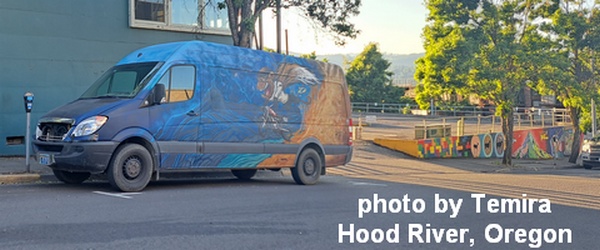
Sprinter Van of the Week!
 Click here for the Sprinter Van map of the world!!!
Have an awesome day!