Mt. Hood Snow Forecast
I hope you like lots of snow, because there’s lots of snow in this forecast! A reminder: Skibowl is opening today! Meadows is open for night skiing Friday and Saturday this week (not Saturday and Sunday like I said yesterday – I was really tired and making mistakes yesterday). For today (Wednesday) on the hill, you can expect clear sky and temps in the single digits. The free air freezing level is all the way down to your house. Wind will be light and variable early, becoming SE 20 in the afternoon. Continued after the chart…
 |
4a-8a | 8a-12p | 12p-4p | 4p-8p | 8p-4a |
|---|---|---|---|---|---|
| Wednesday 0′ |
 |
|
|
|
|
| Thursday 0′->???->3000′ |
 |
 |
 |
|
|
| Friday 3000′->1500′ |
|
|
|
|
|
Mt. Hood Snow Forecast, continued…
Thursday quickly turns cloudy with snow starting up sometime between 8am and 10am. Models are still disagreeing on whether we’ll see a switch to something-other-than-snow for a period of this system. I’m going to play conservative, worst-case-scenario, and say this: The snow level will be at the surface (your house), slowly rising to 6000-6500′ for a brief period between 1pm and 7pm. The snow level will then drop back down to 3000′ (unless you’re in the Gorge). In the 24 hour period from 4am Thursday to 4am Friday, we’ll see approximately 1.5-1.7” water value (WV). I think .5” of that will fall as rain, sleet, needles, or freezing rain. The rest, 1.2” or so, will fall as snow before and after the mixed precip, for 12-16” of new, depending on the density. Wind on Thursday will be SE 25 early, switching to SW20 in the warm period and picking up to SW 35 overnight.

Say “thanks for the forecasts”
by making a donation!
Keep the forecasts coming.
Does this forecast save you time, gas money, or help you have more fun in your life? Make a donation to support continued forecasting, and get the forecast in your inbox each day. Click on the button to donate. The email subscription isn’t $99/year. Not $50/year. No, just $12.34 or more gets you on the list for 12 months. Don’t PayPal? Send a check to Temira @ PO Box 841 in Hood River. Thank you for your support and thank you for trusting my forecast.

Mt. Hood Snow Forecast, finished
Friday looks very snowy. The snow level will be 3000′ or less early, dropping to 1500′ in the afternoon. We’ll see .7” WV between 4am and 4pm, for 7-9” of dry snow. We’ll see another .7” overnight, for 8-11” of even drier snow. Wind on Friday will be SW 35 early, turning to WSW 40 in the afternoon and W 40-50 after midnight.
Saturday looks snowy during the day with flurries overnight. The snow level will be 1500′ or less all day long. Current model runs snow us receive .7” WV between 4am and 4pm, followed by just a little snow overnight. With temps this cold, we’ll see 8-10” of new snow during the day. Wind on Saturday will be W 40-45 all day. Come to think of it, that kind of orographic effect might give us even more snow than models predict. Sunday looks partly cloudy with flurries. Total snowfall between Thursday and Sunday will be 3-4 feet. Ha ha ha ha ha. That’s AWESOME!
Simcoe Accounting
Simcoe Accounting, LLC is a full-service accounting firm. Serving clients throughout the Columbia gorge, dedicated to providing our clients with professional, personalized services and guidance in a wide range of accounting and business needs. We believe in getting it right the first time. The right service at the right time, at the right price. Contact us for a free quote by clicking the headline above.
Gorge Wind Forecast
The easterlies are already at it this morning. Expect 20-25 early, 40-50 by 4pm, and 60+ overnight. That’s at Rooster. Take off 25% for Steven’s Locks. Thursday starts off with E 60+mph at Rooster and slowly backs off just a little bit after 4pm, dropping to E 30-35 after midnight. During this period, there will be massive snow and ice accumulation. Friday starts with E 30-35. By 4pm, we’ll see west wind at Rooster and continuing easterlies at Cascade Locks.
Jones, Sauvie’s, Coast Beta Test Forecast
If you click right here , you’ll find NOAA’s coast forecast.
Random Morning Thoughts
Let’s be all practical and s**t again this morning, because we’ve got a massive storm coming in. In preparation for the storm, I put plastic over the inside of my windows yesterday. If you have old windows, this is an inexpensive fix that’ll keep your house warmer.
The only problem is that it will annoy off your cats, because they will no longer be able to sit in the windows making funny noises at the birds.
You can pick up one of these window covering kits at any hardware store for about $10. The plastic won’t really impact your view, especially if you take the time to shrink the plastic with a hair dryer. Speaking of hair dryers, you can use yours to get snoseal to soak into your boots better. There. Two practical tips for today. If you’ll excuse me, I need to put my huge pot of chicken stock outside to cool. Have an awesome day!
Disclaimer required by my grad school program: I am not your therapist (but I could be 51 graduate school credits from now). I am your weather forecaster. Take everything I say with a grain of salt, and consult with your actual therapist about your mental health issues. One other thing: I plan to keep doing this forecast indefinitely, even when I am a therapist.
Gorge Weather Forecast
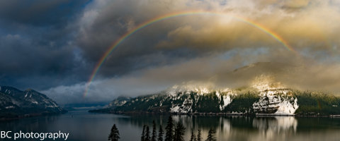
Are you ready? Today starts off with The Nothing, maybe becoming partly cloudy in the afternoon. Enjoy that sun, because it’s never coming back. Temps will be in the upper 20’s to low 30’s all day, dropping into the low 20’s tonight. No precip. No rainbows. East wind.
Thursday starts off cloudy. Snow starts falling sometime between 8am and 10am with the snowfall rate picking up in the afternoon. It’s really hard to tell when we’ll go from snow to freezing rain. My best guess is that we’ll see a period of freezing rain between 1pm Thursday and 7pm Thursday, followed by a switch back to snow, then another period of freezing rain on Friday morning. We’ll see 6-8” of snow and .25” of ice by 4am Friday. Strong east wind. No rainbows.
Friday starts off with freezing rain. If we’re very lucky, we’ll see a switch to rain in the afternoon. Temps will be in the upper 20’s early and the mid 30’s (if we’re lucky) in the afternoon. We’ll see .7” WV between 4am Friday and 4pm Friday. If nothing changes in the models, that will all fall as freezing rain. Uh oh. We’ll see more rain (please let it be plain old rain) overnight. East wind will eventually (hopefully) switch to west wind. .1% chance of rainbows.
Cascade Locks will see at least double these accumulations. The upper valleys will see a LOT of snow.
For weather specifically directed at travel through the Gorge, please visit Temira’s Awesome Travel Advisory Service on Facebook.
White Sprinter Van of the Day

Road and Mountain Biking
Today is your last chance to go mountain biking for a while unless you have the ability to ride in snow and ice. I’d like to remind you that we are into freeze-thaw season. If you ride thawed trails, you will do massive damage. So, please only ride trails under a canopy. No Whoopdee, no Syncline. This is your last chance to do a road bike before the roads are covered in gravel.
Upcoming Events
It’s Wednesday morning. There’s community meditation at Flow at 8:15. There’s community yoga at the FISH food bank at 10am. There’s ping pong at the Hood River Armory at 5pm and Zumba at the Parkdale Community Center at 6:30pm. Coming up Saturday, there’s a fundraiser run for HRVHS at the Waterfront Park at 8:30am.
Have an awesome day today!
Temira