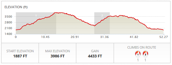
Distance: 52 miles
Climbing: 4433′
Starting Location: Trout Lake, WA
Catchphrase: “Maybe, just maybe, the most awesome ride in the Gorge.”

This ride is nothing short of awesome. Really. Seriously. How can you not like blacktop forest roads with minimal traffic? How can you not like old-growth trees. And waterfalls? And babbling brooks and rushing streams? The roads usually open up mid-June, but call the Mt. Adams ranger station to see if the 23, 90, and 88 road are clear of snow and downed trees.
Some advice: bring a third water bottle, iodine tablets, and plenty to eat, because this ride takes you to the middle of nowhere. There are a couple of gravel sections, so be prepared with 2 tubes, a patch kit and a pump.
Sound intimidating? Ride this as a group ride. The Mt. Adams Country Bike Tour is the way to go. You can do this ride, the BZ-Glenwood ride, or combine them for 100 miles.
Now. The ride description. Park at the Trout Lake School, a mile or so before the town of Trout Lake, or find a spot in Trout Lake. Mileage points are from the store in Trout Lake.
Follow the main road past the store. At 1.2 miles, veer left onto Forest Road 23 toward Randle. At this point, you’ll pedal a series of rolling hills, culminating in a long, sunny climb with stellar views of Mt. Adams. That’s 2000′ of climbing out of the way.
After this, the road winds through the forest, past several streams and a very lovely waterfall. At 20.25 miles, take a left on Forest Road 90. Descend. Enjoy the pavement. You’re going to hit about 200 yards of gravel once you’re on the flats. Don’t worry. It’ll be over soon.
At 27.4 miles, take a left on Forest Road 88. Climb. Climb Climb more. Climb through a couple of short gravel sections. That’s another 1100′ of climbing.
Then you’ll hit some beautiful smooth blacktop, mostly flat, before you hit the descent to Trout Lake. Finish on 5 miles of flat road and get a huckleberry milkshake at the store.
Have fun.
Directions:
0.0 Head north
1.2 Veer left on NF-23
20.25 Veer left onto NF-90
27.4 Turn left onto NF-88
Keep riding.
52 Drink huckleberry milkshake
One reply on “Trout Lake Loop”
One very important comment. Agree you should not do this alone!!!!!
I did the loop last Sunday. First hill part is very long and strenuous. Directions are great until I got to forest road 88. There is a sign saying the road is closed. Not sure if I could get through but cycling back up 10-15 miles of a hill and completing total of 60 miles did not make sense. So I risked it and my life!
I met two people at the beginning of the road who had no idea about it. And these were the only 2 people I met for 20 miles. After 5 miles I came to a barricade and it was REAL clear why it was closed. There was a washed out culvert about 20-30 feet deep and 30-40 feet across. I had to carry my bike down a deep gravel embankment and climb up the other side. I did fall but fortunately did not get hurt. (Not shabby for a 68 year old). There was also a second smaller washout you could push around. There are signs saying the pavement ends but they are not long and also many fallen trees, uneven road and potholes galore. It is down right freaky being on this road alone. In the end you can do i it but more warnings are appropriate.
Recommend taking the route off the list and tell the forest service to put up more signs warning cyclists they can’t get through. Signed by a survivor. It really should be listed under “if you like pain”.